


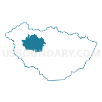
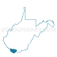
Voting District 105, McDowell County, West Virginia
About
Outline

Summary
| Unique Area Identifier | 691173 |
| Name | Voting District 105 |
| County | McDowell County |
| State | West Virginia |
| Area (square miles) | 43.32 |
| Land Area (square miles) | 43.11 |
| Water Area (square miles) | 0.22 |
| % of Land Area | 99.50 |
| % of Water Area | 0.50 |
| Latitude of the Internal Point | 37.41696580 |
| Longtitude of the Internal Point | -81.77454990 |
Maps

Graphs
Select a template below for downloading or customizing gragh for Voting District 105, McDowell County, West Virginia


Neighbors
Neighoring Voting District (by Name) Neighboring Voting District on the Map
- Voting District 100, McDowell County, WV
- Voting District 102, McDowell County, WV
- Voting District 106, McDowell County, WV
- Voting District 107, McDowell County, WV
- Voting District 109, McDowell County, WV
- Voting District 111, McDowell County, WV
- Voting District 113, McDowell County, WV
- Voting District 116, McDowell County, WV
- Voting District 20, McDowell County, WV
- Voting District 21, McDowell County, WV
- Voting District 78, McDowell County, WV
Top 10 Neighboring County Subdivision (by Population) Neighboring County Subdivision on the Map
- Sandy River district, McDowell County, WV (6,327)
- Big Creek district, McDowell County, WV (5,607)
- Browns Creek district, McDowell County, WV (5,362)
Top 10 Neighboring Place (by Population) Neighboring Place on the Map
Top 10 Neighboring Unified School District (by Population) Neighboring Unified School District on the Map
Top 10 Neighboring State Legislative District Lower Chamber (by Population) Neighboring State Legislative District Lower Chamber on the Map
- State House District 22, WV (33,043)
- State House District 21, WV (15,681)
- State House District 23, WV (14,616)
Top 10 Neighboring State Legislative District Upper Chamber (by Population) Neighboring State Legislative District Upper Chamber on the Map
Top 10 Neighboring 111th Congressional District (by Population) Neighboring 111th Congressional District on the Map
Top 10 Neighboring Census Tract (by Population) Neighboring Census Tract on the Map
- Census Tract 9545.04, McDowell County, WV (4,876)
- Census Tract 9538, McDowell County, WV (3,243)
- Census Tract 9539, McDowell County, WV (2,224)
Top 10 Neighboring 5-Digit ZIP Code Tabulation Area (by Population) Neighboring 5-Digit ZIP Code Tabulation Area on the Map
- 24801, WV (3,858)
- 24844, WV (1,810)
- 24817, WV (954)
- 24872, WV (783)
- 24879, WV (657)
- 24881, WV (601)
- 24811, WV (599)
- 24813, WV (511)